Think of the Earth as one big hot mess of rocky tectonic plates floating around on a sea of hot molten metal. When these plates move and rub together they release huge amounts of energy, causing earthquakes. But what is the biggest earthquake ever?
It is estimated that there are 20,000 earthquakes a year across the world, which is roughly 55 per day. Of these, around 16 will be classed as major (magnitude 7 or above) in any given year.
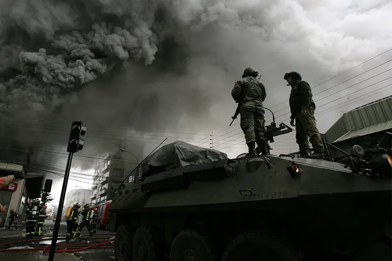
Most earthquakes happen on the sea bed, meaning that the main risk of danger to life occurs from huge tsunami waves hitting land following an undersea earthquake.
The Richter scale helped to standardise earthquake magnitude measurements in the 1930s, making it far easier to compare their relative sizes. However, this scale was flawed and has since been superseded by the moment magnitude (Mw) scale, which we have used in our top ten.
Just like the Richter scale, the moment magnitude scale is logarithmic, which means that for each whole number you go up on the scale, an earthquake gets 10 times more powerful. For context, that means that a 9 Mw earthquake is 1,000 more powerful than a 6 Mw.
So here are the 10 largest earthquakes ever recorded.
10 – Indian Ocean, 2012
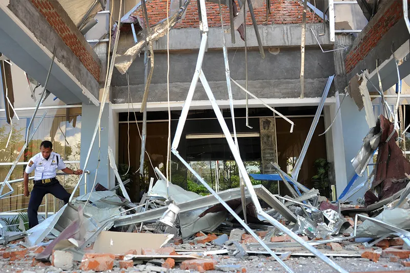
The Indonesian province of Aceh is no stranger to seismic activity. But on 11 April 2012, a huge 8.6 Mw earthquake 610km off the Banda Aceh coast was recorded, followed closely by another that registered 8.2 Mw. The strength and location of these earthquakes sparked a mass panic, sending terrified people fleeing from coastal areas.
Actual damage was low with minor building damage reported in some areas, and the feared tsunami wave never actually materialised.
The seismic event was the largest-ever recorded example of a strike-slip earthquake. This happens when the crust on either side of two tectonic plates moves against each other horizontally, as opposed to vertically.
These types of earthquakes are also far less likely to cause huge tsunami waves compared to a vertical strike-slip fault.
9 – Aleutian Islands, USA, 1946
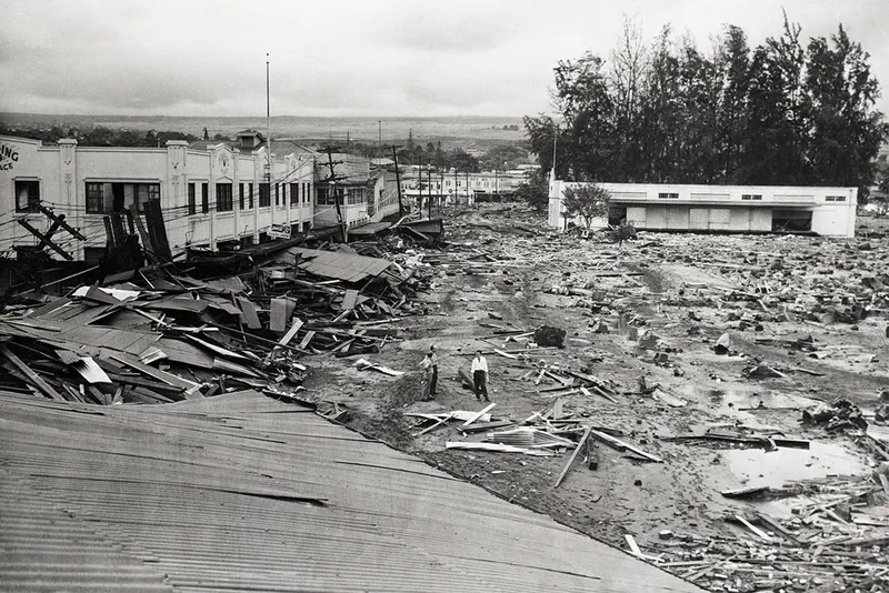
In the North Pacific Ocean, the Aleutian Islands are located between Alaska (USA) and the Kamchatka Peninsula (Russia). In April 1946, an 8.6 Mw earthquake caused a widespread tsunami travelling at a reported 800km/h right across the Pacific Ocean, causing widespread devastation.
This huge wave reached the Hawaiian Islands a mere 5 hours after the quake, covering a distance of over 3,900km. In the resulting carnage, 159 people were killed and many buildings were flattened.
Hawaii wasn't the only place to experience the waves caused by this earthquake. Wave heights at Unimak Island, close to the epicentre, were recorded as high as 42m. Even Antarctica, over 15,500km away, experienced tsunami waves from this huge quake.
8 – Assam, India, 1950
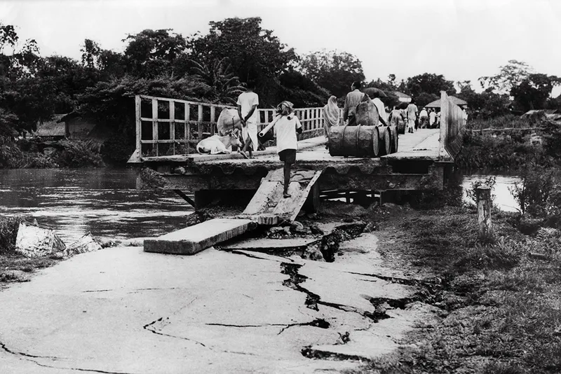
The strongest earthquake ever recorded on land took place between Assam in India, and Tibet, with an epicentre located in the Mishmi Hills of northeastern India. This huge quake was caused by two continental plates (the Indian Plate and the Eurasian Plate) colliding.
In Tibet, this 8.6 Mw earthquake caused massive landslides and land cracks, and whole villages slid into rivers and were washed away. Meanwhile, India too experienced large amounts of damage where 70 villages were destroyed by landslides and the collapse of natural dams.
It is estimated that approximately 4,800 people were killed by this event, with over 1,500 in India and 3,300 in Tibet.
7 – Rat Island, USA, 1965
The Rat Islands are part of a wider chain of volcanic islands known collectively as the Aleutian Islands. These islands are located on the border between the Pacific and North American tectonic plates, and as a result, tend to experience a lot of earthquake activity.
An earthquake on Rat Island in 1965 caused a tsunami wave over 10m in height on Shemya Island 304km away. Even in Hawaii, USA, the resultant tsunami wave generated by the Rat Island earthquake reached 1m in height despite being 4,200km away from the epicentre.
Thankfully, despite the power of this earthquake, reported damage and casualties were minor, mainly due to the sparse population in the area.
Read more:
- Something strange is happening to Italy's underground volcanoes
- The top ten largest cities in the world
- What would a magnitude 10 earthquake feel like?
- The greenest cities in the world
6 – Chile, 2010
An 8.8 Mw earthquake rocked the coast of central Chile in the early hours of 27 February 2010, close to the coastal city of Concepcion. The intense shaking lasted around 3 minutes and was felt as far away as Sao Paulo, Brazil, 4,620km away.
Concepcion has a long history with earthquakes. In 1939, large parts of the city were destroyed by powerful shockwaves and 28,000 people lost their lives. The city was then subjected to further large quakes in 1953 and 1960, which again caused significant damage and loss of life.
Because the 2010 earthquake was so large and had been caused by a rupture under the ocean, tsunami warnings were issued in a total of 53 countries. The wave that was triggered reached both Japan and the Californian coast in the USA.
5 – Severo-Kurilsk, Russia, 1952
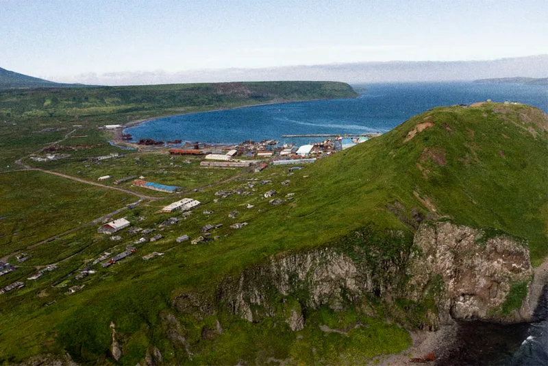
Severo-Kurilsk is on the Kuril Islands, Russia, a small volcanic archipelago 1,300km northeast of Japan. In 1952 nearly half of the population of this small town was wiped out when a huge 18m wave flattened the whole area.
The earthquake had alerted the population of the town to the risk of a possible tsunami wave. Residents made their way to higher ground for safety but returned after the first wave hit, thinking that the danger had passed. The second wave subsequently claimed many lives as people returned to their homes.
Following this disaster, the town was rebuilt on higher ground. To this day, this is still the biggest earthquake recorded in Russia.
undefined
4 – Tohoku, Japan, 2011
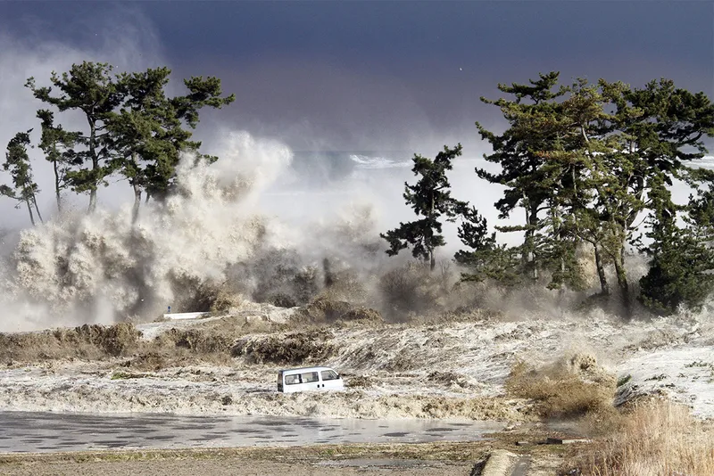
The Tohoku earthquake and tsunami occurred on 11 March 2011 and is the biggest earthquake earthquake recorded in Japan to date. Its epicentre was located approximately 72km off the northeast coast of Honshu (the largest island of Japan) and was so powerful it was later estimated that the Earth had been shifted on its axis by between 10 and 25cm, while Honshu was moved 2.4m east.
The immense power of the tsunami wave was one of the most shocking aspects of the disaster, sweeping away whole towns and villages and easily breaching defences that had been installed after previous tsunamis.
With tsunami waves of over 40m being recorded in some areas of the coastline, planners had not anticipated waves of this height when seawall protection had been constructed.
Just as shocking were the events at the Fukushima Daiichi nuclear power plant, where the tsunami destroyed the power supply. This resulted in a loss of cooling to the reactor cores which in turn caused a meltdown and significant release of nuclear material into the atmosphere.
In total, it has been estimated that over 22,000 people lost their lives as a result of this huge earthquake.
3 – Sumatra, Indonesia, 2004
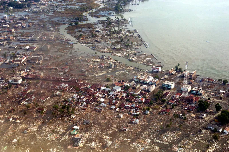
This huge 9.1 Mw earthquake that ruptured a 1,300-km-long segment of the Sumatran megathrust plate boundary was centuries in the making and was caused by the Burma microplate overriding the India tectonic plate in a process known as subduction.
This huge rupture caused an uplift on the ocean floor of over 20m and created a devastating tsunami wave that reached over 30m high. This terrifying wave hit coastal areas in 14 countries, killing an estimated 228,000 people with Indonesia, Sri Lanka, India and Thailand suffering the most deaths.
It remains the most powerful earthquake ever recorded in Asia, and the worst natural disaster of the 21st century.
2 – Alaska, USA, 1964
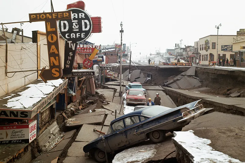
Large areas of North America were affected when nearly 1,000km of fault along the Pacific-North American tectonic plates ruptured at once, causing an earthquake which shook for nearly 5 minutes.
The city of Anchorage sustained large amounts of damage, being only 121km from the epicentre. The damage was further exacerbated by the lack of earthquake-resistant buildings and infrastructure. As a result, many buildings collapsed and pavements and roads sank.
The 1964 Alaska earthquake remains the second-most powerful recorded earthquake in history and the most powerful earthquake in US history.
1 – Valdivia, Chile, 1960
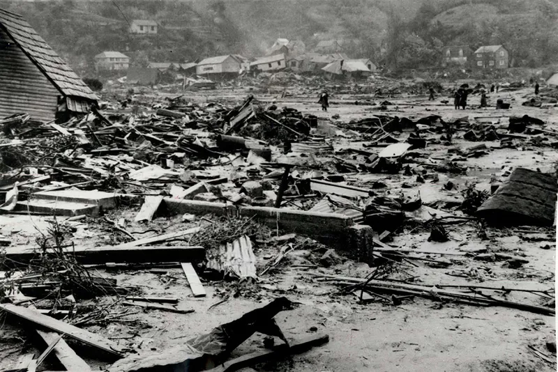
The biggest earthquake ever recorded occurred in 1960 near the city of Valdivia, Chile. With a magnitude of 9.5, it was one of the deadliest earthquakes in history, killing an estimated 5,700.
The quake struck at around 15:00 local time and lasted for 10 minutes. The earthquake caused a large amount of land subsidence along a long stretch of Chile's coast, and many landslides were also reported in rural areas, blocking local roads.
This huge earthquake caused widespread damage and devastation mostly from the resultant tsunami waves along the coast.
Two days after the earthquake, the Cordón Caulle volcano (part of the Puyehue-Cordón Caulle Volcanic Complex in the Andes mountains) erupted as a result of the seismic activity, ejecting ash and steam into the atmosphere. This eruption lasted 59 days in total but caused little damage.
Thanks to a series of powerful foreshocks, Chileans had already been alerted to the danger of a more powerful earthquake being imminent. This probably helped to limit the number of casualties overall.
| Location | Date | Magnitude (Mw) | |
| 1 | Valdivia, Chile | 22 May 1960 | 9.5 |
| 2 | Alaska, USA | 27 March 1964 | 9.2 |
| 3 | Sumatra | 26 December 2004 | 9.1 to 9.3 |
| 4 | Tohoku | 11 March 2011 | 9.1 |
| 5 | Kamchatka, Russia | 5 November 1952 | 9.0 |
| 6 | Chile | 27 February 2010 | 8.8 |
| 7 | Rat Island | 3 February 1965 | 8.7 |
| 8 | Assam-Tibet | 15 August 1950 | 8.6 |
| 9 | Aleutian Islands | 1 April 1946 | 8.6 |
| 10 | Indian Ocean | 11 April 2012 | 8.6 |
Read more: