At past midnight on a Thursday night in June, researchers in Utah are still sending excited emails, updating each other on the day’s action. The team has just finished following a huge fire that has ripped through a remote area of the Fishlake National Forest in the south of the state. And they’re still buzzing.
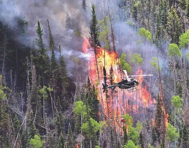
This was no wildfire. It was intentionally set. Early in the afternoon, ignition helicopters were sent in to start the burn. Utah University atmospheric scientist, Adam Kochanski, watched the flames unfold.
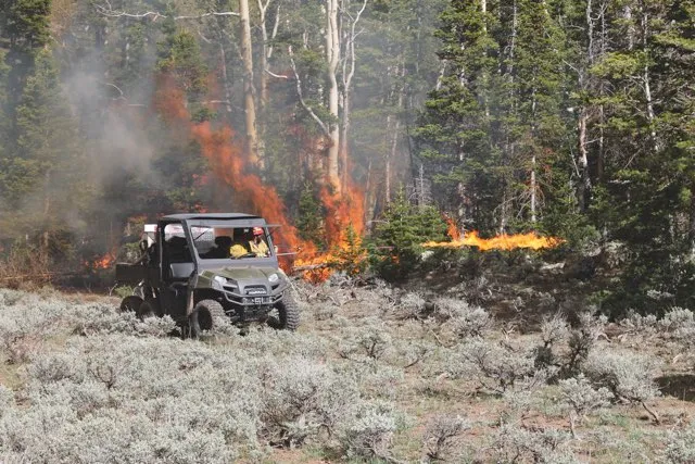
“There were two helicopters with so-called heli-torches – kind of like flame-throwers – just suspended beneath,” he recalls. “They were flying back and forth, and on top of that there were some ground crews with handheld torches and they also started fires on the ground.”
It took a while to get going, but once it did, the fire burned fast and heavy for a couple of hours, consuming eight kilometres of national forest before petering out into the night.
Burning ambition
For Kochanski, this was a unique opportunity to test something that he’d been working on.
A few hours before the burn, he’d been sitting at his computer, using a model he was developing to try to predict how the fire would pan out. “It was the very first time we were able to initialise those forecasts in the field, just in the middle of nowhere – everything on the fly and on your laptop,” he says.
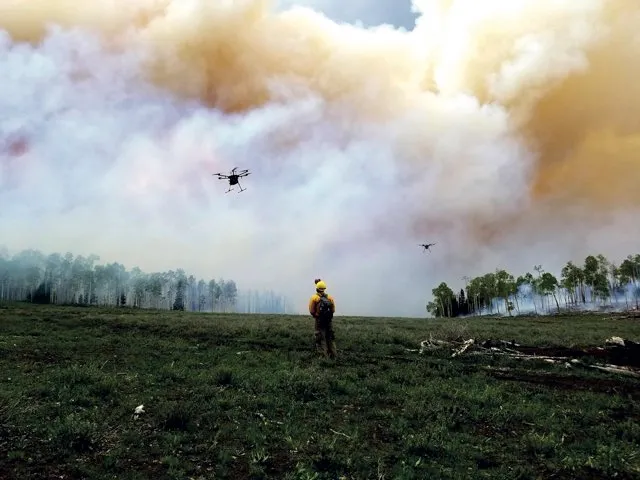
Meanwhile, other researchers were using drones fitted with infrared cameras, laser scanning techniques and instruments on towers dotted around the forest to track every aspect of the fire, the smoke that came off it and local conditions such as wind speed. It was one big experiment.
Read more about natural disasters:
But not just one big experiment. Perhaps you’re wondering why it’s okay to start a fire in a national forest, even if it is in the name of science. Well, that’s not quite all that happened. As Nancy French, a Michigan Tech University scientist who helped coordinate the team, explains, the fire was happening anyway. It was what’s known in forestry as a ‘prescribed fire’ or ‘controlled burn’, one that’s set to achieve some ecological aim. In this case, it’s for habitat restoration. The fire was carefully planned and managed to make way for young aspen trees, which are grazed by elk.
“This area was overmature spruce and now they will be really encouraging it to turn into habitat that’s preferable for the elk,” says French. “So that’s the reason for the fire and what we were doing as scientists was piggybacking on top of that.”
In fact, the scientists didn’t have much say in how or when the fire happened. With prescribed fires, it’s the ‘burn boss’ – someone experienced in setting these type of fires – who is in charge of decision-making.
The number one goal is safety: if there is any sign of drought or dangerous burning conditions, the fire gets cancelled. The burn boss gives the thumbs-up only when conditions are first, safe, and second, likely to achieve the ecological aims. In fact, in June’s Fishlake fire, the decision to burn came after a period of deep snow, when the ‘fuels’ – what fire scientists call trees, along with other stuff that burns – were dry enough.

When it was clear the burn was going ahead, the scientists came, laden with instruments, to study every aspect of it. An advance party had already looked at the ‘fuels’ before the fire and would return again afterwards to see what burned. Then there were researchers involved in studying how the fire itself behaved, monitoring the smoke plume and the chemistry of the smoke. “It’s a pretty big operation,” says French.
As well as scientists, forestry staff and safety coordinators, there was even someone with the dedicated task of de-conflicting – basically, ensuring that the drones weren’t up at the same time as the helicopters.
So what did the scientists get out of this giant blaze? According to French, it will take six months to a year to really unravel the results, but the hope is that they will have a rich set of experimental data with which to furnish a new generation of fire and smoke behaviour models.

These cutting-edge models – dubbed ‘coupled fire-atmosphere models’ – will combine information about the fire and the local weather conditions to produce more accurate forest fire forecasting. As Kochanski explains, the current models don’t account for how the fire itself affects the weather.
“For wildland fires, there’s so much energy that the fire can generate its own weather,” he says. “So it modifies local winds, it modifies temperature, it can generate huge clouds. It can generate precipitation, just because of the moisture coming from the fire.”
Fire distinguisher
A fortnight after the big burn, Kochanski shares the forecast he created for the fire at Fishlake over Skype. It’s a little rough: a two-dimensional rendering of the fire from above, superimposed over a map of the forest, with little arrows pointing in the direction of the wind.
The fire is in grey and there’s a wandering puddle of blue that’s supposed to represent the smoke plume. As Kochanski runs the simulation, the plume grows and spreads, then retreats, before disappearing. Here, the model predicted that rain would set in and that’s exactly what happened in reality. After two hours of burning, the rains arrived and the fire died out.
On the face of things, it seemed like the model worked well. The team was even able to decide where they should view the fire from without getting smoked out, based on their model’s predictions about where the smoke was going to go. But according to Kochanski, the hard work hasn’t started yet.
For wildland fires, there’s so much energy that the fire can generate its own weather
All the data collected on-site has to be incorporated into the model to see whether it is able to capture the real detail of the burn – the height of the smoke plume, the fire intensity and so on. The new data will help the team make some refinements to get it working even better, which means it should produce a more accurate simulation but also, eventually, better forecasting for future fires.
“It’s really updating the knowledge that’s used to make the models operate better,” says French. Some of the sensing technology available now is far more sophisticated, she explains, than what was used to inform older models.
And there are plans to collect yet more data this autumn using one of NASA’s sub-orbital ER-2 planes, a so-called flying laboratory stacked with sensors, as well as a DC-8 passenger plane that will fly through the smoke plume collecting data about its chemistry. It all sounds like first-class science, but the project has struggled due to budget cuts.
From French’s perspective, they now have good quality data, but making use of it could be a thankless task if they don’t find some extra funding. Even Kochanski admits that working up the simulations from Fishlake might be a hobby project until he can figure out how to pay for it.
Despite the funding cuts, many of the scientists on site at the Fishlake fire paid out of their own pockets to be there, which says a lot about how valuable they believe the work to be. It’s partly about the importance of improved models for predicting the behaviour of wildfires.

In the last decade, wildfires have consumed between around 16,000 and 40,000 square kilometres of US land each year, according to statistics from the National Interagency Fire Center, and caused financial losses totalling $5bn (£4bn). Last year, California suffered the largest and deadliest wildfires in its history, with one fire in the north of the state killing at least 85 people. Globally, the stats are just as frightening.
Kochanski says their experiment represents the closest it’s possible to get to a real wildfire while having all the necessary fire and weather monitoring equipment in place. “You can imagine that if a fire is roaring somewhere in California, there is no way to put enough sensors in. There isn’t enough time, there are safety concerns and no one is even going to be allowed to get close to the fire perimeter. So for wildland fire, it’s impossible.”
Ahead of the flame
While a wildfire might be 100 kilometres away from the nearest weather station, the burn area at Fishlake had several stations of its own. Based on this more detailed data, it should be possible to build models and tools that can help the people who have to make decisions about how to fight wildfires. It could help firefighters to know how the fire is likely to behave, so they can be one step ahead.
The improved models could also mean better predictions about where the smoke is likely to go and when. Kochanski suggests early warning systems could give communities more time to react, ensuring that vulnerable groups stay out of the smoke. Schools, for example, could be warned to keep children inside at break times.
Currently, it’s more a case of telling people to stay at home as the smoke is already drifting over their house, when it’s too late because they’ve already made plans. “But if you can provide this information earlier,” Kochanski says, “If you can tell people, ‘hey, between 4pm and 5pm tomorrow, you will be smoked out, so just plan accordingly’, that’s a different story.”
That’s not all though. Improvements to fire modelling could also help forestry workers like those who carried out the prescribed burn at Fishlake. Setting a fire is not normally an exact science. Most of the time, says Kochanski, “they just go with their gut feelings” – albeit based on plenty of experience. They’ve never had the level of data this new experiment provides. It could change the game entirely, helping them to burn more effectively to meet their ecological objectives. Which, at Fishlake, could work out well for the elk.
Once you appreciate everything that’s riding on this experiment, it’s not hard to see why the scientists were so eager for it to go ahead – or why they were so pumped when it all went to plan. But that was just the pyrotechnics part. For Kochanski, it’s the nature of the data collection that makes this project “absolutely unique”. So it’s the nitty gritty of the analysis that should prove its worth. This part, it seems, could be more of a slow burn.
Burning issue
Wildfires cause widespread devastation all around the world
- 13,131 - Spain’s average number of annual forest fires between 2006-2015. More than half are thought to be started by arsonists.
- 9,500 - Distance travelled, in kilometres, by smoke from Russian forest fires in July 2018. The smoke reached Greenland.
- 14,000 - The maximum number of firefighters deployed simultaneously to fight forest fires during peak fire season in California in 2018.
- 540 - Number of people evacuated from their homes in 2018’s Treuenbrietzen forest fire in Germany.
- $26m - A palm oil company’s fine for burning 10 square km of Tripa Forest, where tigers, elephants, rhinos and orangutans still coexist.
- 41,000 - The area, in square km, of US forest burned by fire in 2015. This is the greatest annual loss to fire in the US since records began.
- 39m - The amount of methane, in tonnes, released by forest fires each year. Methane is a more potent greenhouse gas than carbon dioxide.
- 25 - The speed, in km/h, of spreading bushfire during the State Mine Fire, Australia, in 2013. It burned 4.5 million square km.
Follow Science Focus onTwitter,Facebook, Instagramand Flipboard