Think of a rock. It’s angular, grey and on the ground, right? Wrong. Rocks come in a staggering variety of shapes and colours, which help us decipher the stories of their geological lives. Here are just a few of the fantastic rock formations found on this planet…
Ah-Shi-Sle-Pah, New Mexico, USA
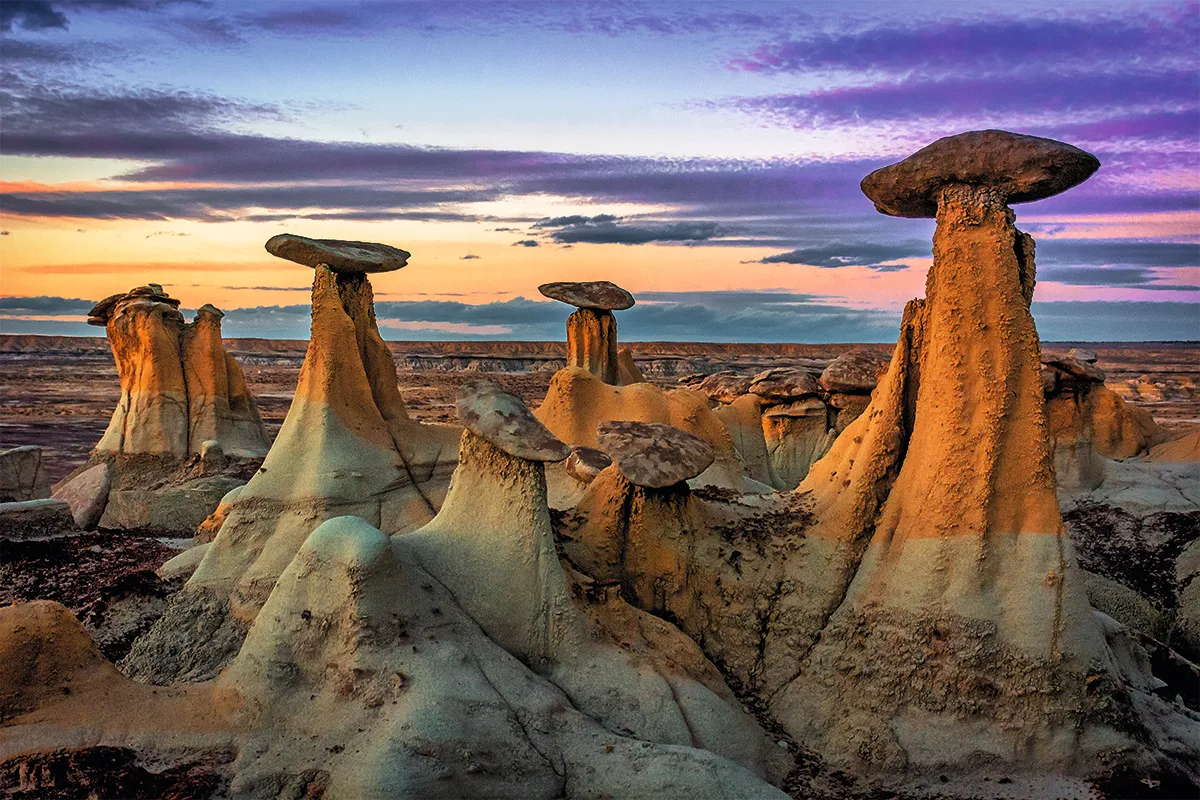
“The Ah-Shi-Sle-Pah Wilderness can feel like an alien planet, with its strange shapes, colours and lack of vegetation,” says Stan Allison, of the Bureau of Land Management Farmington Field Office. The hoodoos – irregular columns of rock – dotted around the landscape also help create that otherworldly quality.
Hoodoos are a lesson in differential erosion: the stronger sandstone resists the erosion that acts on the softer surrounding rock to create spires and precariously balanced capstones. Elsewhere, the ground is so soft that rain cuts vertical sinkholes into hills, carving mazes of ravines and gullies.
The Ah-Shi-Sle-Pah Wilderness is also home to fossilised turtles and crocodiles – a lurking reminder that the parched desert was a humid swamp only 75 million years ago.
Tsingy de Bemaraha National Park, Madagascar
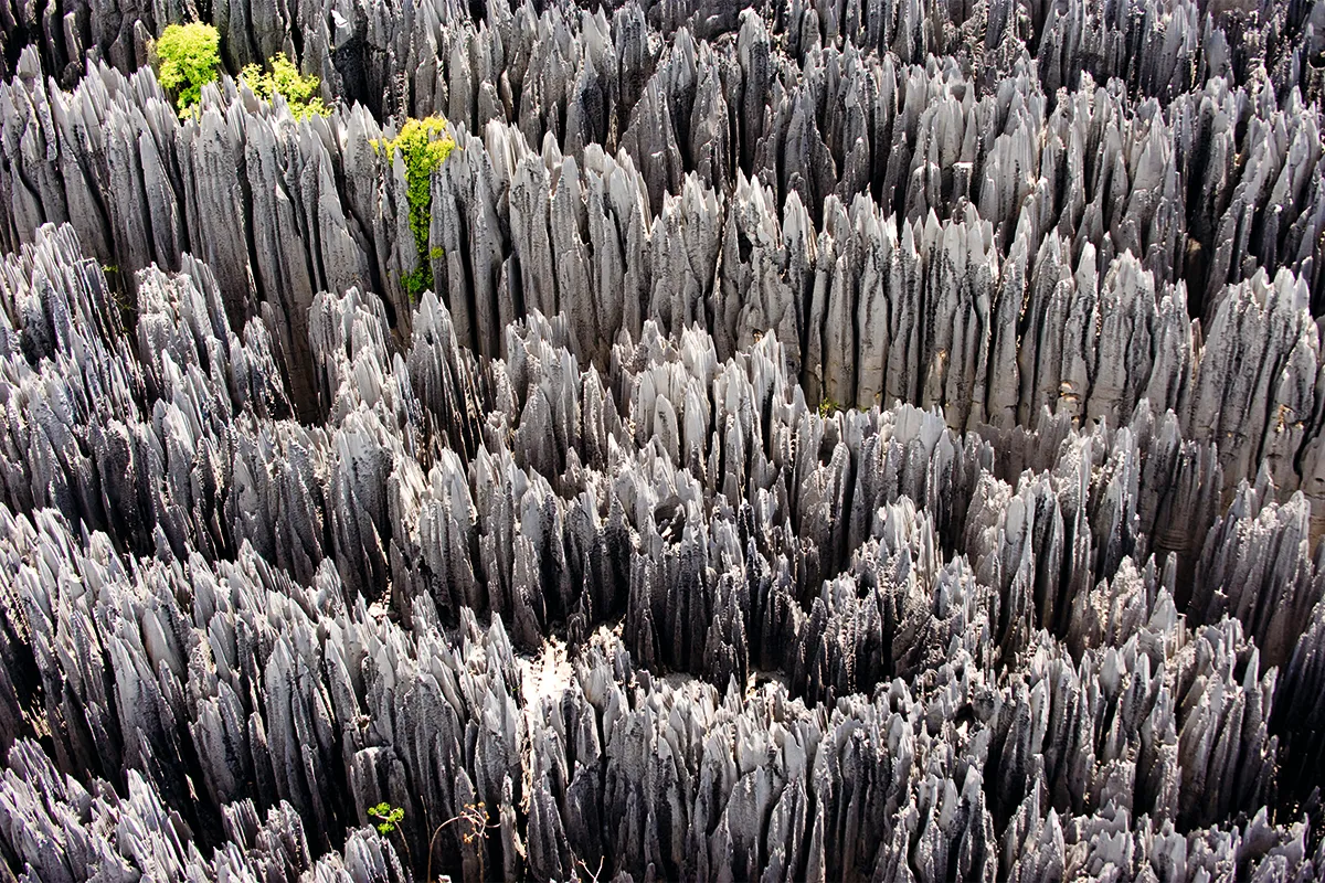
This vast field of rocky spires is the spectacular remains of a lagoon from the age of the dinosaurs. The clints and grykes (patches of limestone pavement separated by cracks) are enhanced by a subterranean labyrinth of caves that collapse and deepen the grykes.
The structure began to form 200 million years ago when calcium carbonate built up on the bottom of the lagoon. It was compacted into limestone before being exposed by tectonic uplift and falling sea levels. In the millennia since then, monsoons carved out the soft rock while acidic rain etched scalloped edges along the jagged needles.
The rocks create microclimates and isolated biomes filled with a rich diversity of life, and scientists have documented endangered and unique species within the harsh landscape.
Luray Caverns, Virginia, USA
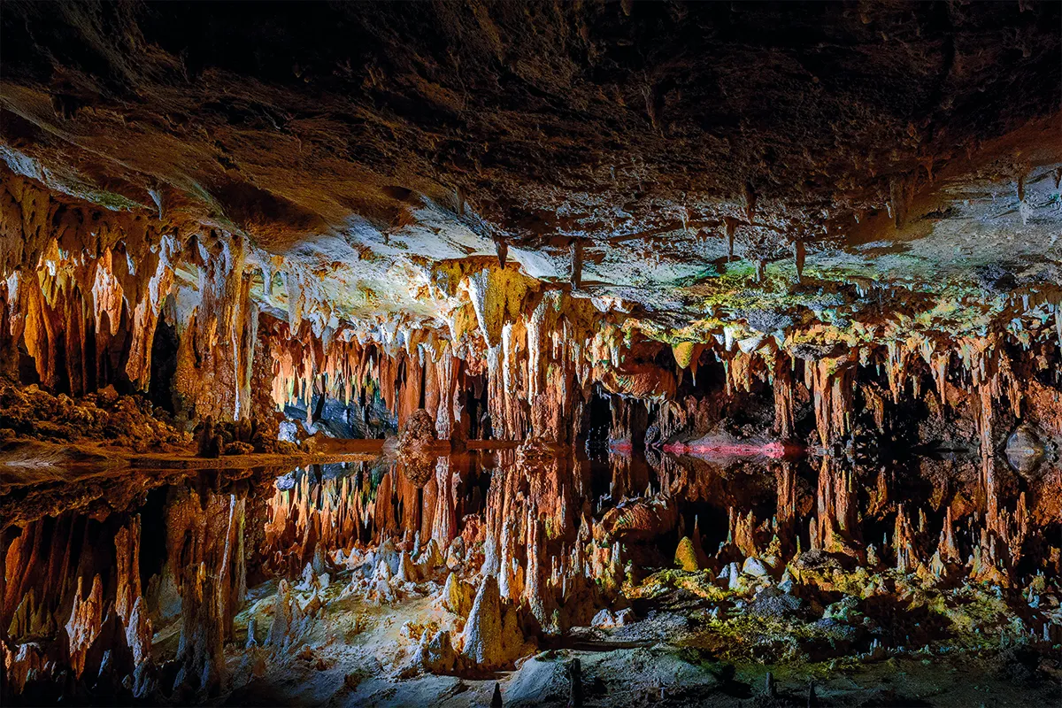
Almost half a billion years ago, ancient tidal flats and a warm, inland sea filled the Shenandoah Valley. The sediment of the flats hardened into limestone, shale, sandstone and dolomite, only to be crumpled into the Appalachian Mountains as the North American and African plates collided.
For millions of years since then, rain has been dissolving the softest of these rocks, infiltrating its way deep underground to create rivers that hollowed out vast caves.
As mineral-rich water dripped into Luray Caverns, it created thin deposits of crystallised calcite that formed into fantastic shapes called speleothems, some tinted red, yellow or brown by the iron oxides of ancient red ocean clays. The walls are coated in huge, sheet-like flowstones where water trickles down corrugated cave walls.
The shapes continue to evolve, with deposits and crystallisation adding, inch by slow inch, to the dangling spikes.
Rainbow Mountain, Peru
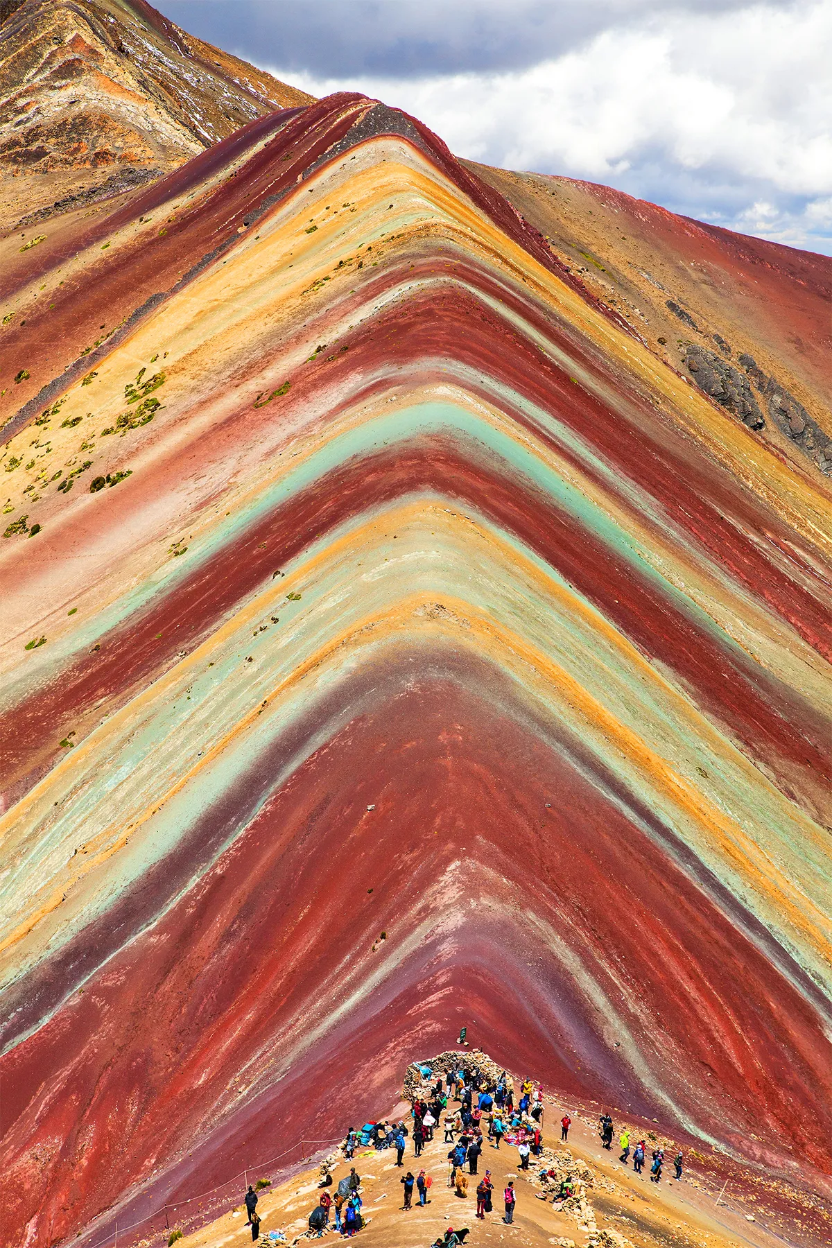
Hidden high in the Peruvian Andes and only recently revealed by melting glaciers is a 20-million-year-old mountain of many colours. Vinicunca (‘rainbow’) Mountainis part of the range formed by the Nazca plate subducting under the South American plate.
The slopes owe their brilliant colours to traces of metals and minerals. The warmer hues are from iron oxide clays and iron sulphides, while the lavender colourscome from mudstone and opal. Green layers of phyllite sparkle with mica blended with chlorites.
While now protected from miners that were tempted by the metals in the soils, Rainbow Mountain is still under threat. The soft soils compress easily underfoot,so to preserve it, the mountain is currently closed to tourists.
Mono Lake, California, USA
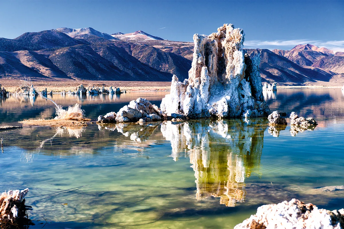
Dammed by ancient lava flows, Mono Lake is where nearby streams and rivers come to an end. Without any outflow, minerals and salts build up as water evaporates. Calcium dissolved in spring water erupting from the lake’s bed reacts with the high concentrations of carbonate in the alkaline lake, crystallising to form tufa towers.
Originally forming underwater, the tufa towers have been exposed by falling lake levels. Their intricate forms contain secrets of their environmental history, with different minerals reflecting the changes in temperature over the millennia. The towers’ locations tell stories of former lake levels over tens of thousands of years, and how that may be linked with greater climatic events, such as changing sea levels, ice ages and the movement of the polar jet stream.
While the exposed towers are slowly weathered and eroded by the elements, new towers continue to form below the water, currently revealed only by trails of bubbles breaking the surface.
Reynisdrangar, Iceland
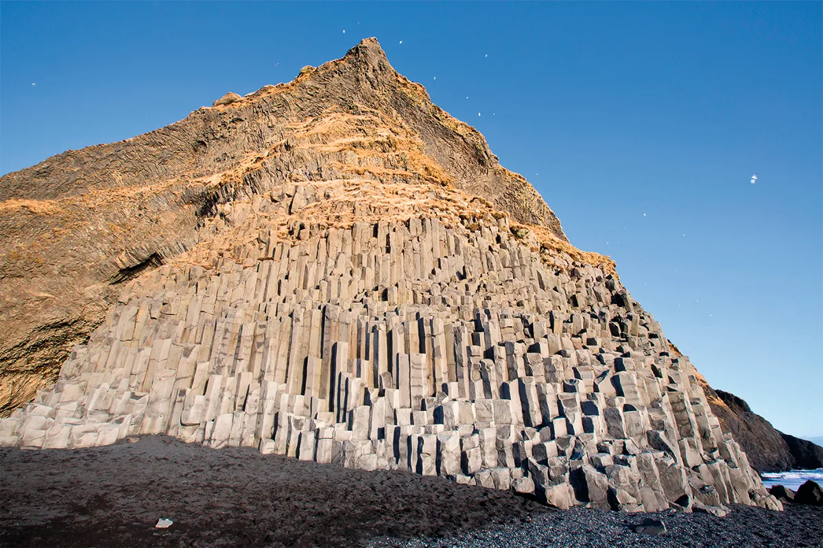
During the last Ice Age, Reynisfjall, a volcano located beneath a glacier, erupted. Lava quickly cooled as it hit the ice, hardening into dark, basaltic rock. The rock contracted as it cooled, causing web-like cracks to form. This created the towering hexagonal columns of Reynisdrangar sea stacks that loom over Reynisfjara beach.
Fierce winds and waves from the Atlantic cut away at the cliffs, with salt crystals helping to open those cracks further until rocks break free. Relentless waves grind those rocks even smaller, replenishing the black sand of Reynisfjara beach.
Geologically, the Reynisdrangar sea stacks visible from the beach are the most resistant rocks that survived while the rest of the cliffs eroded away. But local folklore tells a tale of trolls wading into the ocean to chase a ship, only to get caught and turned to rock by dawn sunlight.
While spectacular, the ongoing erosion makes Reynisfjara a treacherous destination, prone to sudden rockfalls and powerful waves.
More great image galleries from Science Focus:
- Fantastic images of the incredible Sturgeon supermoon from around the world
- The winning images from this year's Nature Through the Lens Competition
- Turning the spotlight on dementia with some stunning images
Coyote Buttes, Arizona/Utah Border, USA
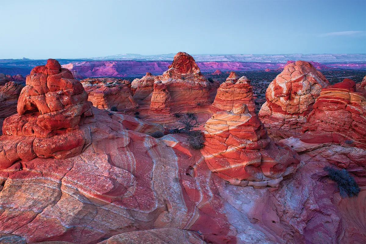
Back when dinosaurs roamed the Earth, wind blew sand across vast dunes in what is now Arizona. As the winds changed direction, the sand built up one way then another, gradually forming rippling, cross-bedded layers.
Dinosaurs crossed the dunes, leaving footprints in the muddier slurry, along with swirled sediment from tiny landslides.
Over the years, water rich with iron and manganese salts cemented the dunes into bright red rocks, petrifying their dramatic, swirling shapes. As the supercontinent Pangaea broke apart and tectonic forces lifted the rocks, rain and wind carved troughs between the dunes, funnelling greater airflow into the gaps that increased the erosion even more and helped create the formations we see in Coyote Buttes today.
“The dunes are frozen in time, capturing the shape of the ancient slopes that, in some places, are slumped and contorted,” explains University of Utah geoscientist Dr Brenda Brown.
“The rocks here tell a marvellous and complex story of changing environments that are affected by so many factors: climate, life, chemistry and time,” Brown says. “We can see how the chemistry of groundwater has changed throughtime and how those changes are recorded in the colourful minerals that cement them together.”
Hyden Rock, Australia
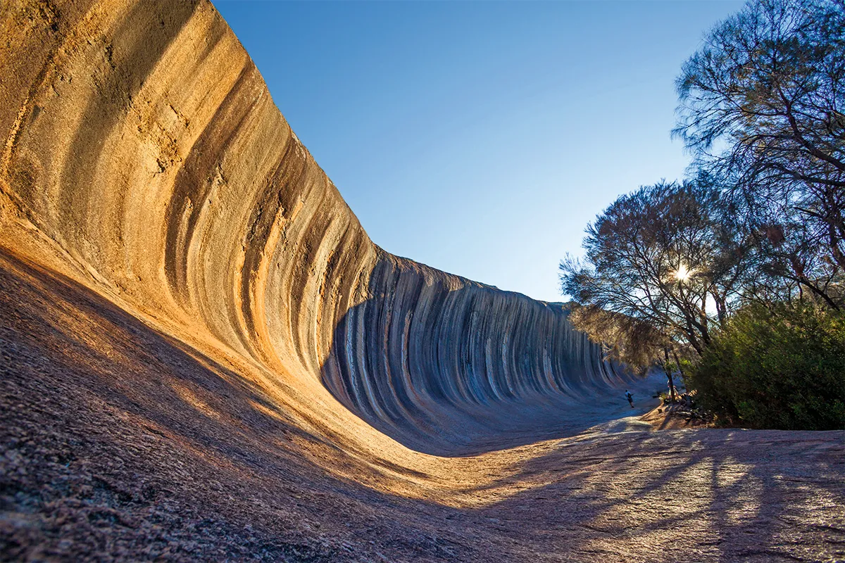
The 110m-long, 14m-tall granite outcrop of Hyden Rock looks like a petrified wave crashing in the desert. The structure is an inselberg, an isolated mountain of hard rock, that jutted above the flat plains of the outback desert 60 million years ago. Exposed like this, the rock has been carved by rain, blasted by sand, cracked by frost and smoothed by rivers to create the distinctive shape.
During the wet season, runoff stains the rock face with stripes of iron oxides and carbonates in red, brown, yellow, and grey.
The indigenous Ballardong people of Western Australia say that the ‘wave rock’ was formed by the wake left by the Rainbow Serpent’s crossing after she’d swallowed all the water of the land.
Bryce Canyon, USA
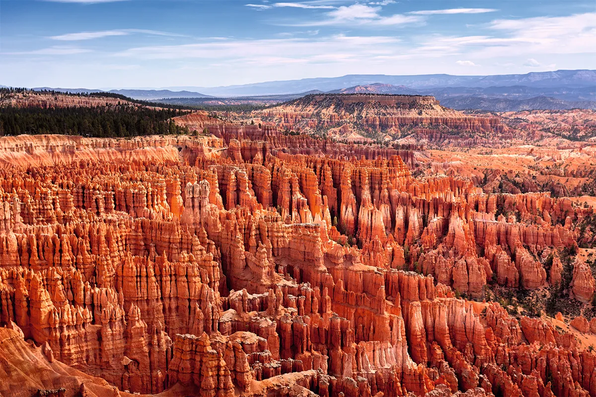
Bryce Canyon is home to the world’s largest hoodoo field. According to the Southern Paiute people, hoodoos are individuals that were transformed to stone by the trickster god Coyote, as punishment for bad deeds. Geologists have a different explanation for the origin of these strange stone columns. Water from rain or melted snow seeps into cracks along the crater rims and expands as it freezes overnight, before thawing again as temperatures climb. This freeze-thaw cycle is repeated until eventually the rock breaks. Slightly acidic rain falling onto the limestone and calcium carbonate also eats away at these weaker rocks, while stronger rocks remain untouched, enhancing the dramatic shapes.
The hoodoos of Bryce Canyon are a temporary sight – once broken free of the canyon rim, the hoodoos continue to erode at an average of 60 to 130cm per century. In about three million years the canyon will have backed into the Sevier River.
- This article first appeared in issue 380 of BBC Science Focus Magazine - find out how to subscribe here
Read more about rocks: